Showing posts with label tornados. Show all posts

Monday, September 10, 2012

Storm Chasing: Don't Try This At Home


Hopefully everyone enjoyed the introduction to Justin Pletsch over the weekend. If you missed it, here's the link:


Now for his storm chase story, in his words. The pictures are well worth it. And I do love the areas where he has traveled in order to get these photos in the plains states of Nebraska, Iowa, South Dakota, Colorado etc.


Today's setup was mediocre at best. Models were indicating storm development in Wyoming (WY) and moving into South Dakota (SD), as well as some weaker storm along the Colorado (CO)/Nebraska (NE) border. With that in mind, we drove west out of Valentine, NE toward Chadron, NE in order to get further west and see what would happen. After a very brief pit stop in Alliance, NE, we made our way south to Bridgeport, NE to figure out where to go. After some more analysis, we chose to head north in the even that storm should fire in WY and move east. In addition, we were in the Nebraska Panhandle, so the road network is really quite abhorrent. There is only 1 good North-South option (US Route 385) and 1 good East-West option (US Route 20).We found an old, abandoned house to take pictures of while waiting for storm development to initiate in-between Alliance and Sidney, NE.


After waiting for a while, nothing was happening to the north in the Ardmore*, SD region, which was one of our targets. Meanwhile, a storm blew up near the CO/NE border, which was our second possible target. We chose to start working our way south toward this cell, which was a good 90 minutes away, while monitoring the area near WY/SD. Fortunately, that storm was moving to the ENE at a slow pace of 15 mph. We intercepted this storm near Sidney, where we encountered 1 inch hail stones. This was quite an interesting storm, as there were 2 cells popping up very close to it, and we could see 3 storm bases quite clearly. One of the bases seemed to be getting bigger, and it started to look more and more "interesting." We followed this to Lodgepole, NE, where it became an LP (low-precipitation) supercell. The structure was absolutely phenomenal!!! It had very nice "barber pole" structure, which eventually turned into a more laminar (stacked) supercell. We stopped near a wheat field to take pictures of this amazing storm, where the sunlight, golden wheat, and a small farmstead provided the perfect background.
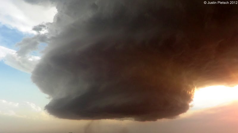

Later, this supercell transitioned from LP to "Classic" mode, and that is when we started to notice "nubs" dangling from the storm base. 2 of these nubs had areas of rotating dirt underneath, which meant 2 tornadoes had formed. Keep in mind these were not textbook by any means, but they were still neat to see, considering LP supercells rarely produce tornadoes. We stuck with this storm for quite some time, and it kept getting better. Eventually, a very nice "clear slot" formed, which was a sign the storm was starting to re-generate. As we were jockeying for position yet again, rain started falling in this clear slot, which usually results in tornado development. One of the tour guests noticed a very ominous lowering in this rain shaft, which turned out to be a funnel. We were unable to stay long because of how much lightning was being produced from this storm. The radar return showed a very distinct hook echo, but it did not last long. As we pulled off the road one last time to take our final pictures, we were treated to an amazing light show to end the evening. This made our drive to Imperial, NE, where our hotel was for the night, much more enjoyable. Our total mileage for the day was 510 miles.

*There was a very photogenic tornado that formed near Ardmore later that evening after we bailed on the SD target. This goes to show that storm chasing does have its ups and downs, but we were still fortunate to chase the storm we did :-)


I want to thank Justin for taking the time out of his day to send me his story, photos and his interview.


Saturday, September 8, 2012

Introducing Justin Pletsch ~ Storm Chaser!


I have always had a fascination with weather. If I'd been a little better at my studies I probably would have done something with that, as well as all the other things I wanted to be. At any rate I enjoy watching weather clouds, and the formations during a storm.


Today I want to introduce to you a colleague and friend, Justin Pletsch, who had an interesting summer chasing storms. He sent me pictures and his story of the chase one day, but I told him I think an introduction is in order. Because aside from being a crazy bus driver (as am I), he does something even more crazier than driving around NIU avoiding students who seem to want to walk out in front of a 12 ton bus. He chases storms, and does so for a company. Well, I'll let the introductions begin and get out of the way aside from my questions.


ME: First of all, Justin, where are you from?


JUSTIN: I was born in Sterling, IL, and grew up in Prophetstonw, IL, which is about 50 miles east of the Quad Cities. My family and I eventually moved to Gridley, IL, when I was in 5th grade, and then we moved to Normal, IL, when I was a freshman in high school.


ME: Tell us when you became interested in weather, or what one weather event made you excited and want to study it?

JUSTIN: I was always fascinated with weather, but the event that really kick-started my interest happened when I was 6 years old. It was a perfectly clear day, and then everything took a turn for the worse one summer evening. We saw a tornado a few miles away from our house in the country, and my dad was able to film it. While he was filming, our neighbor's tree across the street was struck by lightning. Of course, I thought this was SO cool! But we all ended up retreating to the basement.


ME: Smart move. Okay, everyone knows what a storm chaser is, or I hope they do, but why are they important? What do they do to help us study weather?


JUSTIN: Storm chasers are important because they are sometimes the only way people know of impending danger. Take my personal experience form April 9, 2011. I went chasing with three other people, and we ended up in Mapleton, IA, to seek shelter under a gas station awning from ping-pong sized hail. Even though it was really dark and the sirens were blaring, the lady attendant at the gas station didn't know what was happening. We explained that she needed to take shelter immediately. Sure enough, the gas station power went out, and a tornado formed 200 yards from our location!!! Luckily, no one was killed in that town (which was demolished in this storm), and the worst injury was a broken leg.


In addition, storm chaser can provide information that Doppler Radar is unable to pick up (i.e. size of hail, rainfall rates, whether or not a tornado is on the ground, etc.). Keep in mind, the radar can only detect rotation and/or hail within a storm, but it can't actually detect if a tornado is on the ground, or the size of the hail.


Also, storm chasers are usually the first people on the scene after a devastating storm plows through. Any storm chaser worth his salt will provide first aid to people who need it until help arrives. Plus, we might be the only ones able to pick up a phone and dial 9-1-1, because storms that leave a path of destruction behind often leave people in shock.


ME: So true. Okay, now tell us a little bit about the people/group who hired you to go out and do such a crazy, dangerous job over the summer, and where are they based, and anything else you wish to tell us about them.


JUSTIN: I went on my first storm chasing trip in 2009 with a company called Tempest Tours (TT). This company was founded in 2000 by Martin Lisius, who is also the president of TT. It is based out of Arlington, TX, and they lead tours from the middle of April to the middle of August. The tours leave from Dallas, Oklahoma City, Denver, and Phoenix.


Anyway, I was completely enthralled with my first chase/trip that I knew I wanted to go back again. My next opportunity to go again came in 2011, when my parents decided to send me on another storm chasing adventure as my graduation gift.


My third trip came this past summer, but this one was different. After much persistence, I was able to score a driving position for my trip this year, and I was paid to do so.


ME: Tell us, do you recommend this to anyone?


JUSTIN: Please keep in mind that storm chasing is EXTREMELY dangerous, and it should not be attempted unless you have the experience or go with someone who is experienced. Also be aware that you will need to do quite a bit of driving, which is the primary hazard with this activity. In fact, it isn't uncommon to be on the road from 9 AM until 1 AM--just to give you an idea.


In addition, you will have to deal with other chasers who may not be following the rules of the road when on the scent of a massive storm. This can post problems, especially if you get caught in torrential rain, very large hail, hurricane force winds, or worse--the tornado itself! Wildlife also poses a threat, such as fire ants, snakes, cows,, and other creatures. Also, a storm chaser's diet is quite unhealthy, considering breakfast is the only good meal you might get the entire day. Otherwise, you will have to settle for fast food, or a questionable sandwich from a gas station in the middle of nowhere.


In the end, you need to have a health respect for Mother Nature, if you want to live to tell your tale. The best way for someone to experience storm chasing, no matter how much experience you have/don't have, is to go with a company like TT. They are professionals, and they will never intentionally put you in harm's way. For those who want to shop around, I would also suggest looking at Silver Lining Tours, as they are the only other reputable company out there.


ME: Well, thank you Justin for this interview!


And just to reinforce the warning, I wanted to share a photo from one of his companions who was happy to also share his picture and story about it:
"This is a picture of the vehicle I was in on June 20th, 2012 while chasing a storm near Chugwater, WY. We were filming our 3rd tornado of the day from about 2-3 miles away when the storm unexpectedly started heaving bowling balls at us. We got out of there fast, but not before the vehicle took some major hits, including 2 windshield impacts, one baseball-sized and the other 5 inches or more in diameter (we couldn't stick around for exact measurements...lol). Needless to say, this was one of my greatest chases to date. Can't get much better than 3 tornadoes and 5-inch hail in one day!"


REMINDER: my next post up will be Justin's actual storm chasing event from this year. He has some wonderful pictures I want to share with you, so please do watch for it!

You can visit Tempest Tours at http://www.tempesttours.com/


Sunday, April 15, 2012

Power Outage & Smart Tornadoes?

There's nothing like a power outage to make you realize just how much you depend on electricity. We've had no rain for weeks, and finally this large weather system came in last night. And we got our rain! We had the usual lightning storm--nothing major. At 12:39 a.m. the lights/power went out after something went BOOM!. We got up, I made sure everything was alright with my computer. I even unplugged it. I still don't trust my surge protector 100%. Anyway, we didn't have power come back on until 8:20 a.m. which means we were out for 8 hours. We even went out in the park and pumped water into pails--not an easy task, believe me! And were about to put the camp stove outside to make ourselves some instant coffee--and TADA!--ELECTRICITY!

We made coffee (OMG! it was so good!), and some breakfast. And we put things back into refrigerator, having packed them into the coolers.

When the ComEd truck came by this morning around 6:00a.m., and we saw that the guy was checking the transformer and things in our yard, we at least knew they were looking for the problem. It wasn't here, but obviously they found the problem. Outages were all over the county. 30 people in our area were affected by it.

The news from the mid-section of the U.S. was much worse. Five people died when a tornado hit the town. The tornado actually hit the tower, which supplies the electricity for the sirens. It was almost as if it aimed for it--I know that's impossible, but the sirens didn't go off to warn people. I sometimes think these storms/tornadoes have become smarter, and more ruthless these days.

Tonight will be our turn as the cold front advances after the warm front that will boost our temperatures to at least 80. Things will get rather "dicey" according to meteorologist.

I actually wanted to bring you something more interesting, and will, once I'm able to work on this (research it), about Nicolas Cage possibly being a vampire from the Civil War era (tell me if you've heard this one). I'll try and get my post set up for later in the week so please keep checking in. Hopefully a tornado won't end my ability to do this for ever. If you are concerned, thanks. And if you see me posting both my Monday Coffee Klatch and Tuesday Teasers, you can rest assured we have been spared. These have been some deadly tornadoes lately.

And I'm joining forces with author Carole Gill on her blog Bloody Good Vampires. Once we get things figured out, my books and links will be on the side bar, and we will both make posts on it, plus we plan on a corresponding group on facebook where people can join up--for both authors and readers of vampire, horror/Gothic horror, and the supernatural. More on that as we get things built up.

Hope to see you tomorrow!

Monday, September 26, 2011

The Storm Chasers by Justin Pletsch

April 9, 2011
A few of my Meteorology friends and I were seriously thinking of going chasing today.  We had been watching the weather models all week long (since Sunday), and they were indicating a big severe weather outbreak in Nebraska (NE) and Iowa (IA).  As the week progressed, the models began agreeing with each other, which does not happen too often.  On Wednesday, we made the decision to go storm chasing on April 9 because everything was looking very promising.  Even from 3 days out, the SPC (Storm Prediction Center), had our target area of W IA/E NE under a “moderate risk” for severe weather.  This was very good for this time of year, but we still had our doubts about what would happen.  Whenever severe weather occurs this early in the season, the storms move extremely fast, and that makes those storms very hard to chase.  Anyway, the set-up for April 9 was very good, as there was a large amount of CAPE (gasoline for storms) available in the atmosphere.  This meant there was plenty of instability to get storms to fire.  In addition, moisture was also readily available, thanks to warm/moist advection from the Gulf of Mexico.  There was also plenty of wind shear, which allows the storms to become tilted and become supercellular.  Finally, we knew a lifting mechanism (something to get the initial clouds to form) would be available because temperatures were fore-casted to be in the upper 80s and low 90s for our target area.  With all these in mind, we had the 4 ingredients necessary for severe weather; instability, moisture, wind shear, and a lifting mechanism.

However, there was another issue that we saw could pose a problem, and that was the “atmospheric cap.”  Think of this term as a bottle of pop.  If the lid is completely screwed on the bottle and you shake it up, what will happen?  With the exception of the pop getting very agitated, it will not leave the bottle.  Now, what happens when you shake up this same bottle and remove the lid?  KABLOOEY!!!  The same can be said for our atmosphere on a day when severe weather is probable.  If the atmospheric cap is too strong, the clouds won’t be able to break through, and severe weather will not happen.  When storms do form, they will die almost instantly.  On the other hand, if the cap is too weak, storms will fire too soon and will die almost instantly.  The key here is to have a strong, but breakable, cap.  This will allow the atmosphere to “cook”, and when it cooks long enough, KABLOOEY!!!

On the morning of April 9, the four of us met at the NIU parking garage, and we left DeKalb around 9:15 AM.  We headed west toward Omaha, NE, as this was our initial target city.  After stopping in Des Moines, IA for lunch about 4 hours later, we continued our trek west to Omaha.   We stopped at a gas station to fill up and for a pit stop.  After we looked at weather data again, we decided to head north toward Blair, NE, where we would once again figure out what we would do.  We noticed cloud towers going up in the distance, which was a sign that the cap was starting to break.  Each tower got higher than the previous one, and it was not until the 5th tower went up when we knew something big was about to happen.  Needless to say, we started heading East to follow the newest tower, and it certainly took its time to develop into what would eventually be a supercell.  We got very excited when this tower turned into a thunderstorm and was placed under a severe thunderstorm warning for 1” hail.  This cell was eventually placed under a tornado warning, as Doppler radar indicated very strong rotation within the storm.  We passed through Decatur, NE, on our way to Mapleton, IA and the storm produced a tornado near Decatur after we had left.  Being that this storm was moving east, like we were, we did not get too concerned.
photo by Justin Pletsch

When we were about 2 miles west of Mapleton, we stopped for a brief moment to see what this storm was going to do.  Obviously, this storm was already a supercell, and it was a beast!!!  There were four areas of rotation inside this storm, and they were all rotating around each other.  It was really neat to see this on radar, as it looked like a miniature hurricane.  At this point, this storm was beginning to drop hail the size of quarters, half-dollars, AND ping pong balls.  We decided to head into Mapleton to seek shelter from the hail, so we found a BP gas station and chose to play the waiting game.  Our position was perfect, and we would soon realize just how perfect it really was.  The sirens were blaring in the town, which was a very good sign.  As we were gawking and taking pictures of the storm, the gas station power went out.  Our initial thought was that lightning must have struck some power lines. 
photos by Justin Pletsch

It was at this point when the rotating part of the storm (the mesocyclone) came right over us, and we noticed a “bulge” protruding from the base of this monster.  This “bulge” was a funnel cloud if you were to view it from a distance.  Soon after this feature was pointed out, we saw dust getting picked up about 200 yards away from us.  THAT, ladies and gentlemen, was the tornado ON THE GROUND!!!  I have never seen 4 people get into a car as fast as we did, and our hearts were beating faster than ever!!  We thought about taking shelter in a car wash that was nearby, but we decided to get out of town as fast as we possibly could.  For a few minutes, WE were the ones being chased by the tornado, which turned out to be an EF-3 monster (3/4 of a mile wide).  We stopped VERY quickly to take pics/video of this before we continued to high-tail it out of harm’s way.  However, we got caught between the hail core (dumping baseballs at this point) and the tornado, so we spent what seemed like an eternity trying to get away.  Yes, it was raining, and we knew we were close to the core when we heard a loud BANG on the car.  This was because we were getting pelted by baseballs, so it made the situation even worse. 
tornado on ground photo by Justin Pletsch

After the tornado dissipated, we started to head toward Fort Dodge, IA, where we would be spending the night.  On our way there, we encountered ANOTHER tornado, and I was fortunate enough to get a very brief video of it.  At this point, darkness had come upon us, so we had to rely on the frequent lightning strikes to see what was happening.  We also noticed what appeared to be a very low hanging wall cloud (hills were obstructing our view).  The next morning, we found out that this “low hanging wall cloud” was actually a 2.5 mile wide tornado that stayed in the fields.  We followed this storm to Sac City, IA, and watched as it went through Pocahontas, IA, and dumped grapefruit sized hailstones on the town.  In fact, before it went through, the storm had 2 tornadoes on the ground at once!!!  After enjoying an amazing display of lighting, we finished our trek west toward Fort Dodge.  All in all, this was a very exhilarating chase, even though we came very close to meeting Death face-to-face.
As for the town of Mapleton, 60% of it was completely destroyed by the tornado that went through (including the car wash we were thinking of taking shelter in).  Despite all that, no one perished because of the 20 minute lead time they had.  The worst injury was a broken leg.  This storm was known as a “cyclic supercell”, which means it produced tornado after tornado after tornado.

Justin Pletsch is a GRADUATE of meteorology at NIU.
(underlines and bolds by the blog mistress)

AUDIO BOOK NOW AVAILABLE!

Hi, everyone, I have some great news! My first Sabrina Strong book, Ascension, is now in an audio book format.  NOW THAT I HAVE YOUR ATTE...